|
In English |
|||||||
|
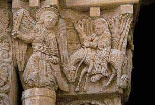
The road was built and maintained by the local nobles. Because it was not constructed with the idea of connecting places of great importance and distance like the Roman roads, it was a series of local paths and trails of various widths and various materials, which linked mountain passes, bridges, ferry boats and villages. However, it had two distinctive characteristics, the first being the location of the places where one could find refuge for the night, closer together if the travelling was difficult and wider apart if the going was easier. The second was the constant danger involved in a trip of great distance: bandits, difficult terrain, wild animals and disease. In fact, because of the constant dangers involved, if one undertook a pilgrimage there was a ritual to be observed regarding the preparations. Usually the pilgrims were men, but women could undertake the trip as well. The person had to pay his debts, prepare a will, receive from his local priest his pilgrim costume, ask forgiveness of anyone whom he might have offended and finally to say goodbye to everyone before leaving. The chances of returning were not all that good.
Many things were specified in the will. For example, his heirs, the purpose of his trip, the length of time he was supposed to be away, and the places he was supposed to visit. This last item was
proven upon his return by the "souvenirs" he brought back. In the case in
which the pilgrim had not returned after the length of time he was supposed to be away, plus one year and a day, his property was
distributed among his heirs. The preparation of the will was followed by his being dressed and blessed by his local
priest or Bishop. By doing this, the individual entered into the "Order" of the pilgrims and he probably wore a kind of habit which consisted in the
11 C of a pilgrim's staff, which was a stout stick with a metal point, of a long
garment of rough texture and dark colour and a leather bag which hung at his waist and which he used for food and money. This
uniform also had various symbolic aspects. For example, the staff, the dress and the bag
representing Faith, Hope and Charity, as well as having been blessed to
protect him against the temptations of the devil and other evils.
The diary of Sigeric begins in Rome and proceeds northwards to Canterbury, but the route is normally described from the north to the south since the pilgrims' main initial objective was to reach Rome.
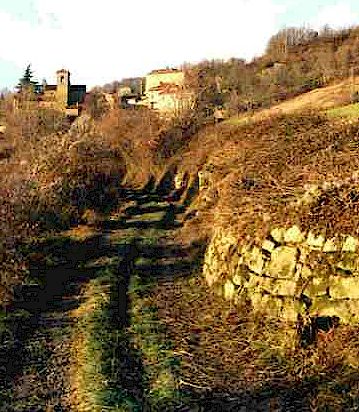
Today the Via Francigena enters Tuscany at the Cisa Pass in the area called Lunigiana north of Pontremoli and heads south toward Acquapendente in Latium passing through Lucca and Sienna. It is still possible to follow approximately the ancient road and to find refuge in most of the same villages mentioned by Sigeric. The route passes through four distinct geographical areas where the landscape, the building materials and the gastronomic traditions follow their own local traditions, occasionally still reflecting mediaeval influences.
The first of these four areas begins at the Cisa Pass, the crossing point from the
Region of Emilia Romagna into the Region of Tuscany, north of
Pontremoli in the Appennine mountains, and follows the valley of the Magra river down to Aulla and Sarzana. This area is called Lunigiana, after the
Roman port city of Luni, today an archaeological site, where marble was sent by ship to the rest of the world,
as from the port of Carrara today. Sarzana, further inland, became an important intersection where the Roman road, called
the Via Aurelia, and the Francigena met. This area is characterised by castles, walled
mediaeval villages and isolated monasteries, constructed primarily of the gray
limestone found locally. These places are never of great size and were built on the steep slopes of the mountains along the principal road and were easily defended. All around these locations there are woods, small tributaries and natural caves.
The third sector is the longest segment of the Francigena and runs from Altopascio, down to Fucecchio, and on to
Sienna passing through Castelfiorentino,
Certaldo, Poggibonsi,
San Gimignano
and Monteriggioni
before it arrives in Sienna. Near Fucecchio, the road goes through very open and flat
land that used to be swamp and which is still the crossing point of the Arno river, and
there are rolling hills beginning near Castelfiorentino. All the cities were walled and the
mediaeval atmosphere is still evoked by the narrow streets, gates and the buildings made
from the local sandstone. The northern part of this sector
passes small industries related to the tanning of leather and to the south
through areas dedicated to the production of wheat, wine and olives. If one stops around Fucecchio, it is possible to
make side trips to places such as Galleno, to see the longest reconstructed stretch of the original Via Francigena
(1150 meters) or to Vinci the home of Leonardo, or Coiano mentioned by Sigeric, but today out of the way. The food is good and so is the local wine. After Fucecchio, one goes near
San Miniato, a
mediaeval village, through Castelfiorentino, Certaldo, Poggibonsi and San Gimignano. This last mentioned village is a very famous
mediaeval walled city, today very active, famous for its 13 C towers and the Collegiata, where Ghirlandaio painted the chapel dedicated to the local saint, Santa Fina. Here again there are many places to
visit - museums, churches and in the area some of the finest vineyards. Not far away there is
Montelupo
known for is pottery and
ceramics.
Next, we proceed to Colle Val d'Elsa,
famous for its glass and crystal industry as well as for its historical
past, and on to Badia a Isola
and Monteriggioni, a splendid walled town. This is where one can again begin trekking and in fact there are remains of the via
Francigena near here as well.
From Sienna south, the Via Francigena closely follows the Via Cassia, another of the old roman
roads. Visits to Isola d'Arbia, Buonconvento, Montalcino,
the Abbey of Monte
Oliveto Maggiore and San Quirico d'Orcia
are all worthwhile. However the last two stops of Sigeric, Bagno Vignoni and Abbadia San Salvatore, are the most spectacular.
Bagno Vignoni
is where for centuries people have gone for health cures because the
sulphur water baths. The Abbey of San Salvatore
is the best conserved of the mediaeval villages with a great Abbey attached. It was already famous in the
8 C.
The "Anglo-Saxon Chronicle", which covers the period from 445 and 1150, records for the year 990 that the Saxon Sigeric was consecrated Archbishop of Canterbury and that in the same year he went to Rome to collect the "pallium" or the investiture mantle from the hands of the Pope, as was customary for that period.
"A.D. 989. This year died Abbot Edwin, and Abbot Wulfgar The voyage of this rather obscure Saxon prelate was nothing remarkable, as it was not different from many similar journeys undertaken by his contemporaries, were it not for the fact that he had it carefully recorded in a diary. This unique and invaluable document was compiled by a member of Sigeric's numerous retinue and offers a succinct account of a typical journey to Rome in the years around 1000 AD. For the Europeans of the early Middle Ages, Rome stood along the way to Jerusalem, and since the 4th century numerous pilgrims had passed through Rome on their way to the Holy Sepulchre. When, in 640, Jerusalem was conquered by the moslem infidels, such journeys came to a halt and pilgrims stopped at Rome. Only after the First Crusade, and only at intervals, did the way to Jerusalem return to being relatively safe.
|
|||||||
)
)
)
)
)